

Image: Max McCaskill
AI has changed the way people plan vacations and outdoor adventures. In the past, when planning something like a camping trip or hike, you had to spend hours researching online, downloading specialized outdoor apps, and maybe even buying a physical map. Today, all it takes is a couple of sentences typed into ChatGPT, Gemini, Claude, or Grok to build an entire personalized trip in just minutes.
The tech news worth knowing, what it means for you, and what everyone else is getting wrong, delivered right to your inbox.
While using AI to plan your trips is a huge time-saver, it’s also dangerous.
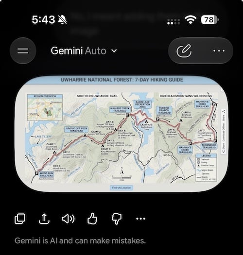
There have now been multiple news stories this year featuring hikers getting lost and needing rescue because they relied on AI models to plan hikes. AI can get trail distances wrong, hallucinate maps, and overestimate your abilities, leading to potentially dangerous results. I even tested Gemini myself to see how it would do planning a seven-day hiking trip at the Uwharrie National Forest in North Carolina. It made multiple errors, and even after I asked it to fact-check its plan, it still missed some of them.
According to Park Superintendent Chip Jenkins, up to 26% of visitors to Grand Teton National Park are now using AI to plan their trips, and that number is not likely to decrease. So, since you may be considering using AI for a future trip, let’s talk about how to do it safely and when you should still use a trusted app and your smartphone instead.
Hi there! I'm Max, and I'm a wireless industry expert. What does that mean? For one thing, I get paid to play on my iPhone. But more than that, it means I've spent years reviewing carriers, testing smartphone hardware, and reporting on the news that impacts your phone bill.
Smartphones and wireless plans are some of the most important pieces of technology in most people's lives, but you probably don't think about them until your plan is too expensive or it's time to upgrade to the newest phone. Unfortunately, that means you miss a lot of interesting and important stuff that can affect your life and wallet. The WhistleBlower is our way of cutting through the noise and flagging the things we think you need to know about.
Want The WhistleBlower in your inbox? Sign up below.
What are the dangers of using AI to plan hikes?
AI makes trip planning incredibly convenient. You simply tell the AI model what you want and then have a conversation as it builds your itinerary.
However, remember that AI aggregates information from across the internet. That information is generally trustworthy if it comes from official sources like the National Park Service, but AI can also pull in user-submitted information like blogs, comments, and outdated YouTube videos, skewing the answers. Even worse, by filling in gaps in its sources, AI can hallucinate things like trails, rivers, road names, and trail distances.
Hikers who use AI information without verifying it’s correct can get lost or misjudge how difficult trails are. Last month, a hiker became stranded on the side of a cliff on Crown Mountain in British Columbia after Claude sent him on an extremely challenging route that got him lost. In September, three hikers had to be rescued from Mount Shasta in California because they used Gemini to plan their trip to the summit. The AI model misjudged how long it would take them to get to the top, and they became lost on the way back down in the dark.
In both cases, the hikers were rescued because they could still use their phones to call for help. While AI got them into trouble, it was their phones and a cell signal that got them out.
My home is close to the Uwharrie National Forest in North Carolina, so it felt like a natural place to test how well Gemini could create a seven-day hiking trip. While its itinerary sounded plausible to someone who isn’t from the area, Gemini’s plan underestimated the route by five miles and hallucinated connections between trails that are miles apart. It also drew a map that made no sense, even misplacing lakes and major highways.
Asking Gemini to fact-check its plan caught some of the issues, but not all of them. Anyone relying on this plan or map could have gotten lost, underestimated the hike’s length, or not taken enough supplies. Plus, while the hikers from Mount Shasta and Crown Mountain had a cell signal to get help, that isn’t guaranteed when you’re out on the trail.
What should I do instead?
None of this is to say you should never use AI for planning time outdoors. I use it all the time to plan rough trip outlines and find hidden gem destinations. However, the important thing is to always verify the information from official sources and rely on trusted apps when visiting, not materials created by AI.
Apps like the official NPS app can offer maps, trail advice, and weather information. AllTrails is another trustworthy source for user-submitted hikes and elevation profiles. Unlike AI, which can use incorrect or outdated information, AllTrails is moderated and allows you to sort by recent posts. Some apps can also offer offline features like trail maps, and you can use apps like Hipcamp or The Dyrt to find safe camping locations across the country.
You should also ensure that your phone is set up for emergencies when hiking or spending time outdoors. Most newer iPhone models and some Android phones have satellite connectivity, and T-Mobile offers a paid T-Satellite service add-on and free 911 texting for everyone, regardless of your main carrier. These features can get you connected to emergency services if you need help or get injured.
AI isn’t going anywhere, and neither are the people using it to plan their next hike. Just remember to treat its itinerary as a rough draft. Fact-check the details, download trustworthy trail apps for offline use, and know how your phone’s emergency features work before you ever leave home.
More from WhistleOut on outdoor smartphone safety
Your smartphone is a great tool for the outdoors. Here are some of the best ways it can keep you safe while you’re exploring:
- How To Enroll In T-Mobile’s T-Satellite 911 Texting: T-Satellite 911 texting is available for free to everyone, regardless of your current carrier. Here’s how to sign up so you’re always prepared for an emergency.
- How To Get Help In The Middle of Nowhere with iPhone Roadside Assistance: Hiking and outdoor activities often involve driving to remote areas. Here’s how you can still get help if you have car trouble with no phone signal.
- 5 Ways To Get Your Phone Ready Before The Next Big Storm: These are great tips you can use if you find yourself stuck in bad weather at home, on the road, or out on the trail.
Max McCaskill
Sr. Staff Writer

Thousands of cell phone plans unpacked. All the facts. No surprises.

Related Articles


Related Topics
Featured Op-EdPopular Topics
Featured App Reviews iOS News Coverage Device Reviews Device Explainers Carrier Explainers App Roundups T-Mobile